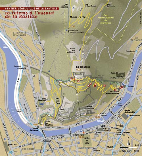
The Bastille is at the southern end of the Chartreuse mountain range. It overlooks the north of the city of Grenoble and the Grenoble « Y » formed by three valleys: to the south, the Gresse and Drac valley, to the north-east, the Grésivaudan valley and to the north-west, the Grenoble-Voreppe gorge. This confluence of valleys is framed by three massifs: the pre-Alpine Chartreuse, Vercors ranges and the Alpine Belledonne range.
There are various ways of reaching the Bastille site:
The most-used method is the cable car. This provides access to the heart of the fort in just a few minutes and attracts tourists in particular. It is open all year and until late in the evening during the summer.
The site is also accessible by car. Only one road leads to the top of the Bastille. It starts after the Town Hall in the township of La Tronche. Visitors do not generally favour this route, due to the narrow, dangerous road. There is free parking for 50 vehicles on the glacis slope behind the fort.
The last way to access the site is on foot! This way is mostly used by residents of the Grenoble area. The Bastille hill has several paths on it connecting the right bank of the river Isère to the top of the fort and to the university buildings further down the hill.
-
From a family walk taking under an hour to a strenuous four-hour hike, the Bastille’s waymarked paths are open to all tastes and every ability.
Paths towards the city
- The Saint-Laurent side of the Bastille
Allow 30 to 45 minutes to walk down and 45 minutes to 1 hour 15 minutes to walk up. Height difference: 300 m – paths and stairs.
From the fort, descend east following the signage to « Porte Saint-Laurent ». This route is not only a cultural stroll around the fortifications, but is also an invitation to get into better shape with its fitness trail. You can use it to access the Musée Dauphinois, the Saint-Laurent archaeological site, the CCSTI Grenoble Scientific, Technological and Industrial Culture Centre or the Museum of Grenoble by crossing the river Isère. More seasoned hikers could take the great staircase, the escalier des géants (giants’ staircase)along the fort’s eastern moat- Bastille Porte de France side
Allow 20 to 40 minutes to walk down and 40 minutes to 1 hour to walk up. Height difference: 300 m – paths and stairs.
From the upper cable car station, walk to the main square and follow the stairs west in the direction of « Porte de France » to find bunkers and firing positions. Follow the route of the Via Ferrata to walk to parc Guy Pape (Guy Pape Park)and then to Jardin des Dauphins (Dauphins’ Park), which has outdoor play equipment for children. This shaded path takes you through a natural plant mosaic providing homes to birds, insects, rodents, butterflies and various birds of prey.- Promenade de la Poudrière (Powder Magazine Walk)
30 minute circular walk with a 50 m height difference or 1 hour to the bottom with 230 m height difference – paths and stairs.
From the fort’s main square (place Tournadre), follow the path and go down to the right, facing the Vercors mountains to explore bunkers, firing emplacements and, in the distance, a watchtower. Follow the wall with its sawtooth outworks. Look down through the trees to catch a glimpse of the citadelle Rabot (Rabot Citadel). You will then have a choice. You can go left to take the path that runs alongside the powder magazine and takes you back to your starting point, or you can carry on along the path that takes you down on the Saint-Laurent side.- From the cavalier to the Mandrin Caves
30 mins. approx., height difference of 30 m, approx., paths and stairs.
Climb the stairs next to the souvenir shop to arrive at the fortified cavalier that housed the cannons aimed towards the Chartreuse. Go back down to the main square and then leave it using the fort’s gate, formerly a drawbridge. Follow the profile of the cavalier and climb the metal stairs to your right, leading into the moat. Leave the moat and walk along the defensive slope, the « glacis », along the road to head towards the « Mandrin » caves using the walkway. According to legend, the famous Dauphinois brigand hid his treasure there, even though he was executed more than a century before their construction!Go down the impressive underground staircase with its over 260 steps and follow the path that will take you back to the entrance to the fort.
- Mont Jalla, National Memorial to French Mountain Troops
30 mins. 140 m height difference – path.
Located on the promontory of Mont Jalla (Mount Jalla) at an altitude of 634 m and accessible by long-distance walking route GR9, the memorial site offers spectacular views of a panorama extending from the foothills of the Chartreuse in the north-east to the Voreppe gorge in the north-west and taking in Mont Blanc, Belledonne, L’Oisans, le Trièves and the Vercors.Paths towards the Chartreuse
- Bastille, regional natural park side
2 to 4 hours and up to several days!
You are at the southern gateway to the Chartreuse Natural Park and it is possible to set off from here on longer walks towards Saint-Martin-le-Vinoux, la Tronche, Mont Rachais, and more. Long-distance path GR9 offers the opportunity to go deep into the Chartreuse Park on multi-day hikes.
Bastille Fort door closing times.
Following several break-ins and acts of vandalism at night, the Fort door will be locked shut during the evening, including for pedestrian access.
- Between 9 p.m. and 6 a.m. when the cable car is closed in the evening,
- Between midnight and 6 a.m. when the cable car is open in the evening.


